Maps with labels

Here’s are the maps with their keys and labels:

 01 every internet connected device - Map D


01 every internet connected device – Map D

 02 World_population_density_1994 - Map G


02 World_population_density_1994 – Map G

 03 internet freedom - Map C


03 internet freedom – Map C

 04 Religion_freedom_map - Map I


04 Religion_freedom_map – Map I

 05 Fibre-World-Map_2 - Map A


05 Fibre-World-Map_2 – Map A

 06 Public expenditure on education - Map E


06 Public expenditure on education – Map E

 07 YouTube access - Map H


07 YouTube access – Map H

 08-land-area-to-population-density - Map B


08-land-area-to-population-density – Map B

 09 the_networked_readiness_index_2013_map - Map J


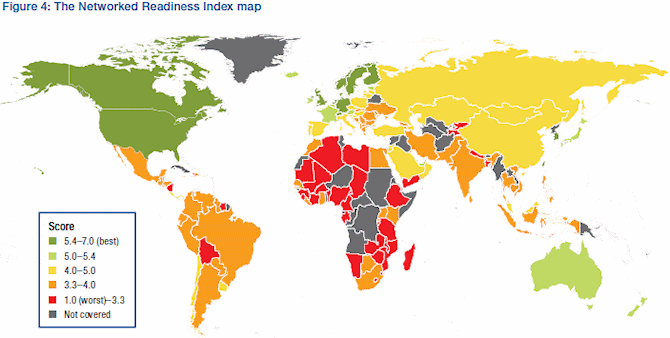
09 the_networked_readiness_index_2013_map – Map J

 10 number of cats - Map F


10 number of cats – Map F

<- Back

References

01 every internet device (http://time.com/3221958/internet-map/)

02 world population density (http://www.google.com/url?sa=i&source=images&cd=&docid=nIhIjeO-_9bJbM&tbnid=xwNVP6v3altSkM&ved=0CAUQjBw&url=http%3A%2F%2Fupload.wikimedia.org%2Fwikipedia%2Fcommons%2F6%2F67%2FWorld_population_density_1994.png&ei=SHgwVPLMCMeBsQTS0IJQ&psig=AFQjCNE-Z1sPc_mjb9gjp028lJQT-VzTsA&ust=1412549064285656)

03 internet freedom (http://www.dailymail.co.uk/sciencetech/article-2737627/Now-s-world-wide-web-Map-reveals-globe-looks-like-internet-device-lit-up.html)

04 religious freedom map (http://commons.wikimedia.org/wiki/File:Religion_freedom_map.png)

05 fiber connected countries (http://www.orcon.net.nz/ufb/blog/fibre_world_map)

06 public expenditure on education (http://mabloom77.blogspot.com/2014/03/who-pays-for-education.html)

07 YouTube access (“YouTube world map” by Ont – Own work. Licensed under Creative Commons Attribution-Share Alike 3.0 via Wikimedia Commons – http://commons.wikimedia.org/wiki/File:YouTube_world_map.png#mediaviewer/File:YouTube_world_map.png)

08 land area to population (http://sasi.group.shef.ac.uk/worldmapper/animations/wm01to02.html)

09 networked readiness worldwide (http://www.ispreview.co.uk/wp-content/gallery/2013-internet-statistics/the_networked_readiness_index_2013_map.gif)\

10 number of cats (http://www.usnews.com/cmsmedia/d4/ee/a43e82f14bc7a8111a908f726f24/140725-mapcats-graphic.54.28%20PM.png)

Leave a comment